
📌 Key Takeaways
- The 50 States Challenge is a fun travel goal to visit all US states in your lifetime
- Our free printable US state map makes tracking your progress visual and exciting
- You can personalize your map with colors, dates, and special memories
- The map comes in multiple formats (PNG/SVG/PDF/JPG) for easy printing and using
- Perfect size (11"x8.5") for framing, travel journals, or office display
- Track your progress with creative coloring systems for different years or trip types
- Great for families, road trippers, and bucket list travelers
🧭 Quick Navigation
- What Is the 50 States Challenge?
- Benefits of Taking On This Travel Adventure
- Why Use a Printable US State Map?
- Creative Ways to Color Your Map
- Mini Facts About States for Your Journey
- Must-See Landmarks in Different Regions
- Tips for Planning Your 50 States Challenge
- Beyond the Map: Other Ways to Track States
- Making It Fun for Families and Kids
- The Perfect Companion: State Postcards Collection
- Additional Resources for Your Journey
- Frequently Asked Questions
What Is the 50 States Challenge?
The 50 States Challenge is a travel adventure where people try to visit all fifty states in the United States during their lifetime. It's like a giant treasure hunt across America! Some super speedy travelers have done it in just a few days (the record is about 5 days), but most people take years or even decades to complete it.
I started my own 50 States Challenge back in 2010 and have reached 43 states so far. What I love about this challenge is that there are no strict rules - you get to decide what counts as "visiting" a state. Some people count airport layovers, while others want to spend at least one night or visit a famous landmark in each state.
🌟 Different Ways People Define "Visiting" a State:
- Setting foot in the state (even briefly)
- Spending at least one night there
- Visiting at least one major attraction
- Having a meal in the state
- Taking a photo at the state welcome sign
The 50 States Challenge is perfect for all kinds of travelers - road trip lovers, families looking for educational adventures, retirees checking off bucket list items, or young people wanting to explore their country. Every state has something special and unique to offer!
Benefits of Taking On This Travel Adventure
Taking on the 50 States Challenge brings so many good things into your life! As someone who's been working on this challenge for years, I've experienced these benefits firsthand.
| Benefit | How It Helps You |
|---|---|
| Discover America's Diversity | Experience different landscapes, foods, accents, and cultures without leaving your country |
| Create Lasting Memories | Build a collection of unique experiences from each state |
| Learn American History | Visit historic sites where important events happened |
| Connect with Different People | Meet locals with various perspectives and lifestyles |
| Grow Through Challenges | Navigate different environments and expand your comfort zone |
I'll never forget driving through Montana at sunrise and seeing a family of moose by the roadside, or trying my first authentic gumbo in Louisiana. These special moments happen when you push yourself to explore new places.
The challenge also helps you appreciate how big and varied the United States really is. The desert landscapes of Arizona feel completely different from the lush forests of Oregon or the beaches of Florida. It's like visiting many different countries while staying in your own!
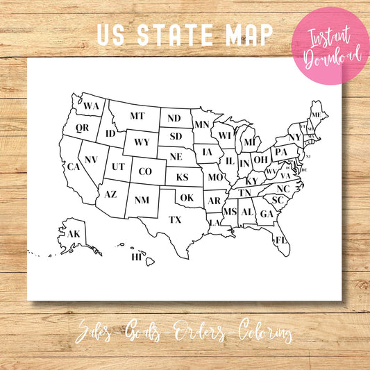
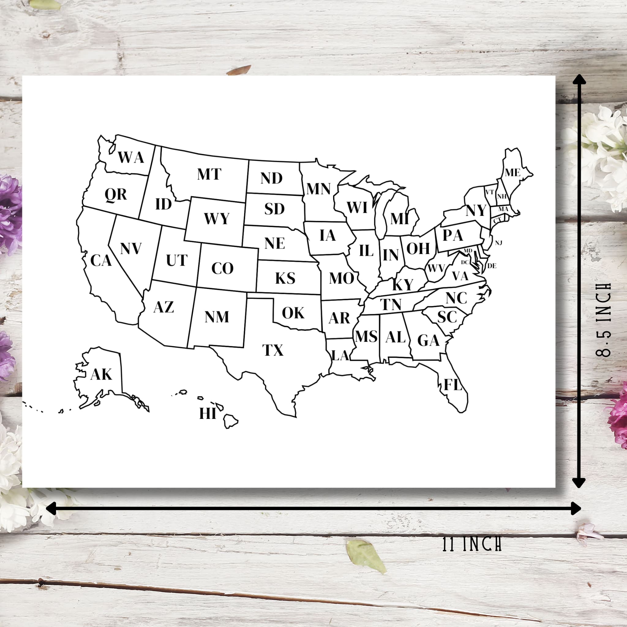
Why Use a Printable US State Map?
Our Printable United States Map is the perfect tool for tracking your 50 States Challenge. While phone apps are useful, there's something special about having a physical map you can touch, color, and display.
✨ Map Features:
- 🗺️ Clear outlines of all 50 states
- 🔤 State abbreviations included
- 📏 Perfect 11"x8.5" size (standard letter paper)
- 🖨️ Multiple formats: PNG, SVG, PDF, and JPG
- 💰 Completely FREE (regular price $2.99)
- ⬇️ Instant digital download
When I started my 50 States Challenge, I used a regular paper map and colored in states with markers. It became my favorite souvenir! I still have it framed in my office, and it always starts conversations with visitors.
The visual aspect of coloring in states gives you a sense of accomplishment as you see your progress grow. It's much more satisfying than just checking boxes on a list or tapping states on a phone app. Plus, you can print multiple copies to try different coloring systems or start fresh if you make a mistake!
Creative Ways to Color Your Map
The best part about having a printable map is that you can personalize it in so many creative ways! Here are some fun ideas for coloring your map to make it uniquely yours:
🎨 Coloring Systems to Try:
Color by Year
- Blue: States visited before 2020
- Green: States visited in 2020-2022
- Purple: States visited in 2023-2025
- Orange: Future planned visits
Color by Season
- Yellow: Summer visits
- Orange: Fall visits
- Blue: Winter visits
- Green: Spring visits
Color by Experience
- Green: Outdoor/nature-focused visits
- Red: City exploration visits
- Blue: Beach/water activities
- Purple: Historical/cultural visits
My family uses a rating system with stars - we color the state and then add 1-5 stars based on how much we enjoyed it. This helps us remember our favorites and places we'd like to return to someday.
You can also add small symbols or icons to your map - a tiny tent for places you camped, a mountain shape for hiking trips, or a small sun for beach days. These little details make your map tell the story of your unique journey across America.
Mini Facts About States for Your Journey
Learning fun facts about each state makes your 50 States Challenge more interesting and educational! As you track states on your printable map, try to learn at least one cool fact about each place you visit.
🤩 Surprising State Facts:
- Alaska: Contains both the easternmost and westernmost points in the US (because the Aleutian Islands cross the 180° longitude line)
- Kentucky: Has more navigable water than any other state in the lower 48
- Michigan: You're never more than 6 miles from a natural water source anywhere in the state
- Arizona: The Grand Canyon is so big that you could fit the entire New York City in it
- Rhode Island: The smallest state has the longest official name: "State of Rhode Island and Providence Plantations"
When I visited North Dakota (state #37 for me), I learned it's the nation's leading producer of honey. I made sure to buy some local honey as my souvenir! Having these little knowledge nuggets makes each state visit more memorable.
Challenge yourself to find unusual facts that go beyond the typical tourist information. Ask locals for weird state laws, unusual traditions, or little-known history. These become great stories to share when people ask about your travels!
Must-See Landmarks in Different Regions


As you plan your 50 States Challenge, it helps to break the country into regions and identify the must-see landmarks in each area. Here's my list of can't-miss spots in each region of the United States:
| Region | Must-See Landmarks |
|---|---|
| Northeast | Statue of Liberty (NY), Acadia National Park (ME), Freedom Trail (MA), Niagara Falls (NY) |
| Southeast | Kennedy Space Center (FL), Great Smoky Mountains (TN/NC), French Quarter (LA), Charleston Historic District (SC) |
| Midwest | Gateway Arch (MO), Mackinac Island (MI), Mount Rushmore (SD), Abraham Lincoln sites (IL) |
| Southwest | Grand Canyon (AZ), The Alamo (TX), Carlsbad Caverns (NM), Monument Valley (UT/AZ) |
| West | Golden Gate Bridge (CA), Yellowstone (WY), Glacier National Park (MT), Denali (AK), Pearl Harbor (HI) |
I always tell people not to rush through these landmarks. When I visited the Grand Canyon, I initially planned just a quick stop to take photos. I ended up staying three days because it was so much more incredible than pictures show!
While these famous spots are worth seeing, don't forget to explore lesser-known attractions too. Some of my most magical moments happened in small town museums, local festivals, and scenic backroads that never make the tourist brochures.
Tips for Planning Your 50 States Challenge

Planning a 50 States Challenge takes some strategy, especially if you want to complete it efficiently. After 13 years of working on my own challenge, I've learned some helpful tips:
🗺️ Smart Planning Strategies:
Cluster Your State Visits
- Plan trips that let you visit multiple neighboring states
- The "Four Corners" monument lets you stand in Colorado, Utah, Arizona, and New Mexico at once
- New England road trips can cover 6 states in just a few days
Start With the Hard-to-Reach States
- Visit Alaska and Hawaii while you're young and have more flexibility
- Plan for remote states like North Dakota or Idaho early on
- Save easy-access states for when you have less time or mobility
One strategy that worked well for me was focusing on different regions each year. In 2015, we tackled the Northeast (10 states in one two-week road trip). In 2017, we explored the Southeast (8 states). This approach made the challenge feel more manageable.
Another tip: use major life events to add states! When attending a wedding in Kentucky, we added a few days to visit Tennessee and West Virginia too. Heading to a conference in Arizona? Rent a car and add Nevada and Utah to your trip. Look for these natural opportunities to expand your map coverage.
Beyond the Map: Other Ways to Track States

While your printable map is the perfect visual record of your 50 States Challenge, there are many other fun ways to commemorate your journey across America!
📸 Creative Ways to Document Your Adventure:
- Photo Traditions: Take the same posed photo in each state (jumping, holding your map, etc.)
- Collection Projects: Gather something small from each state (rocks, postcards, magnets)
- Digital Memory Book: Create a digital album with favorite photos and memories from each state
- Travel Journal: Write about your experiences and attach small mementos
- Welcome Sign Photos: Snap a picture at each "Welcome to..." state sign
My favorite way to track states is through my license plate collection. I take a photo of a license plate from each state I visit. It started accidentally when I noticed an Alaska plate in Washington (rare!), and now I have photos of plates from all 50 states - though only 43 were photographed in their home states!
Another idea I love is the "taste test challenge" - try a local food specialty in each state. From Maine lobster to Texas BBQ to Hawaiian poke, this delicious challenge helps you experience the unique flavors of America. I keep a food diary with notes about the best meals from each state visit.
Making It Fun for Families and Kids

The 50 States Challenge becomes even more special when you do it as a family! Kids love the adventure of tracking states, and it turns ordinary family vacations into exciting milestone moments.
👨👩👧👦 Family-Friendly Challenge Ideas:
- State Passport: Create a "passport" book where kids get a "stamp" for each state
- License Plate Game: Spot license plates from different states during road trips
- Junior Researcher: Have each child research one fun fact before visiting a new state
- Collection Project: Let kids pick a small souvenir from each state
- State Symbol Hunt: Look for each state's bird, flower, or tree during your visit
When my niece and nephew joined our family trips, we created a special game. In each state, they had to find something that started with that state's first letter (Montana moose, Tennessee turtle, etc.). They could draw it or take a photo. This kept them engaged and observant during our travels.
For younger children, start with just recognizing the shapes of states on your map. My friend's 5-year-old can identify Texas, Florida, and California by their distinct outlines! As kids get older, they can take more ownership of tracking their progress and planning which states to visit next.
The Perfect Companion: State Postcards Collection
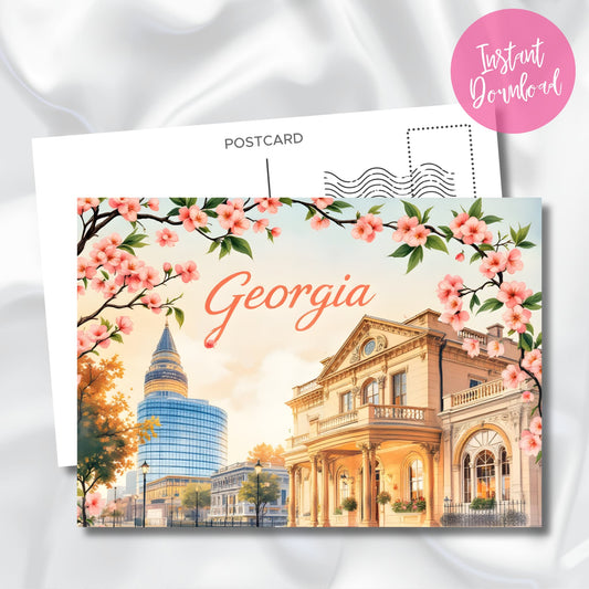
To make your 50 States Challenge even more special, check out our Vintage USA State Postcards: Cotton Blossom Collection. These beautiful digital postcards feature iconic imagery from each state.
💌 Ways to Use Digital State Postcards:
- Print and display alongside your state tracking map
- Create a scrapbook page for each state visit
- Send to friends and family from your travels (print before your trip!)
- Frame your favorite states as wall art
- Use as journal cover pages for your travel diary
What makes these postcards special is that each one features state birds, landmarks, and natural elements specific to that location. The vintage-inspired design gives them a nostalgic road trip feel that perfectly matches the spirit of the 50 States Challenge.
I've used these postcards to create a beautiful travel memory wall in my home office. Each time I visit a new state, I add its postcard to the display alongside my map and a favorite photo from the trip. It's become my favorite wall in the house and a constant reminder of adventures past and future!
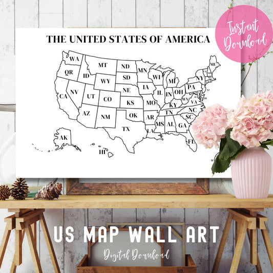
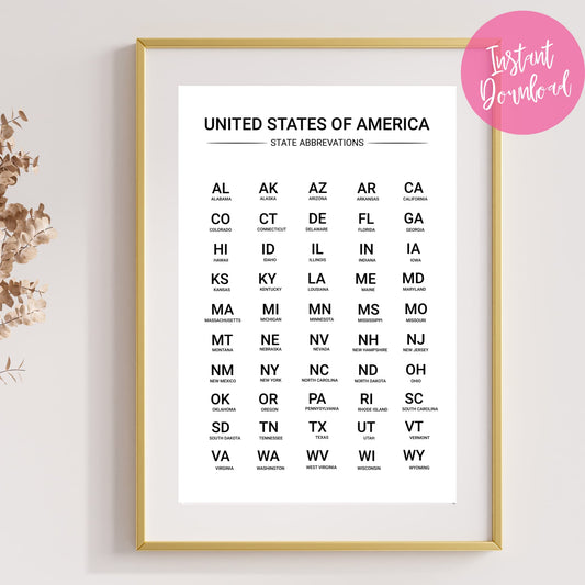
Additional Resources for Your Journey
To help you make the most of your 50 States Challenge, we've created additional free resources that complement your printable US state map:
| Free Resource | How It Helps Your Challenge |
|---|---|
| US State Abbreviations Chart | Learn all state abbreviations for easier trip planning and map labeling |
| USA Map Wall Art (24"x16") | Larger display version perfect for family rooms or classrooms |
Beyond our free printables, here are some helpful tools for your 50 States journey:
🧰 Useful 50 States Challenge Tools:
- Road Trip Planning Apps: Roadtrippers, TripIt, or GasBuddy
- State Tourism Websites: Official sites often offer free travel guides
- National Parks Pass: Annual pass offers entry to all national parks and monuments
- State Capitol Tours: Many offer free guided tours of state government buildings
- Welcome Centers: Stop at state welcome centers for free maps and local advice
When I'm planning a new state visit, I always check the state's official tourism website first. Most states will send you free travel guides and maps just for asking! I still have a collection of these official guides from all my trips - they're full of great local insights you won't find in general travel books.
Local libraries are another often-overlooked resource. Before big road trips, I check out travel guides for each state we'll visit. This saves money and gives us more in-depth information about the places we're exploring.
Frequently Asked Questions
❓ What counts as visiting a state for the 50 States Challenge?
This is entirely up to you! Some people count simply crossing the state line, while others require spending at least one night or visiting a major attraction. There are no official rules - set your own criteria based on what feels meaningful to you.
❓ How can I print my US state map if I don't have a printer?
You can save the digital file and print it at local services like Staples, Office Depot, UPS Store, or your local library. Many of these places offer printing for less than $1 per page. Some people also print on cardstock or photo paper for a more durable result.
❓ What's the best coloring method for the printable map?
Colored pencils work well because they allow for precise coloring of smaller states. Markers can bleed through, so if using markers, place a blank page behind your map. Some people prefer highlighters for a translucent effect that still shows state boundaries.
❓ How long does it typically take to visit all 50 states?
Most people take several years or even decades to complete their 50 States Challenge. The national average is about 12 years for those actively working on it. Some dedicated travelers have done it in under a year with careful planning, while others enjoy spreading it out over a lifetime.
❓ Which states are considered the most challenging to visit?
Alaska and Hawaii are typically the most challenging due to distance and transportation costs. Among mainland states, North Dakota, Idaho, and Rhode Island are frequently among the last states people visit, as they're either remote or not on major travel routes.
❓ Can I edit the printable map file to add my own elements?
If you download the SVG format, you can edit it using free programs like Inkscape or paid software like Adobe Illustrator. The PDF, JPG, and PNG formats are more limited for editing but work well for printing and coloring.
❓ Is there a recommended route for visiting all 50 states efficiently?
Many travelers find success with a regional approach - focusing on New England, the Southeast, the Midwest, etc. For an efficient mainland route, consider the "perimeter strategy" - traveling the outline of the US and then filling in the middle states with targeted trips.
❓ Are there any official clubs or communities for people doing the 50 States Challenge?
Yes! The All Fifty States Club (theallfiftystatesclub.com) offers free membership and certificates for those who complete the challenge. There are also Facebook groups and Reddit communities where travelers share tips and celebrate milestones.